


traversée du col de la charbonniere

CABERMAT
User
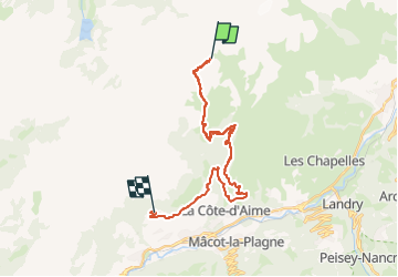

Length
23 km

Max alt
2499 m

Uphill gradient
888 m
Km-Effort
37 km

Min alt
1059 m

Downhill gradient
1610 m
Boucle
No
Creation date :
2025-04-08 07:24:07.178
Updated on :
2025-04-08 12:35:18.563
5h08
Difficulty : Very easy

FREE GPS app for hiking
 SityTrail
IGN / Geographical institutes
SityTrail Plus
The world is yours!
About
Trail Touring skiing of 23 km to be discovered at Auvergne-Rhône-Alpes, Savoy, La Plagne-Tarentaise. This trail is proposed by CABERMAT.
Positioning
Country:
France
Region :
Auvergne-Rhône-Alpes
Department/Province :
Savoy
Municipality :
La Plagne-Tarentaise
Location:
La Côte-d'Aime
Start:(Dec)
Start:(UTM)
317525 ; 5055945 (32T) N.
Comments